NZ Land Logs 32, Year 2: North Island–Cape Reinga
Date: Thursday, March 22, 2007
Weather Today: Overcast AM and PM with a Few Patches of Blue Midday
Location: Cape Reinga, New Zealand
Today was our day to drive as far north as you can drive in New Zealand. We had driven to the southern-most point on the South Island and we just had to replicate the same on the North Island. Unfortunately, the rainy, overcast weather we had for our South Island day was replicated as well. Actually, we had only sprinkles a few times, but our morning and late afternoon were both totally overcast and we actually had fog as we neared Cape Reinga. Once you drive as far as you can, you walk down a path to the lighthouse. As we descended we got a little break and could at least see some of the spectacular coastline below us.
In a town called Awanui we stopped at Ancient Kauri Kingdom Ltd. The Kauri is an ancient tree that grows to great height and girth in New Zealand, but most of the towering forests are gone now. Tomorrow we will be exploring the largest Kauri forest left and you will hear more about this beautiful wood then. The shop were we stopped today sells only items that are made from the ancient kauri buried in the nearby swampland. It is actually carbon dated to be more than 45,000 years old. We enjoyed watching some of the products being made as well as seeing the beautiful end-products. But as I said, more about this tomorrow. From Awanui, we started our drive up the slender peninsula to the “end of the earth.” At least that is how it feels. The paved road goes up the center of the peninsula but there are a few harbors that cut in from the sea right up to the road. At one place we thought the waters were at flood stage as they lapped against the roadside. On the way back down the peninsula in the late afternoon, we realized that it was simply high tide when we drove north as there was no water in sight this second time through. There is another “road” that leads to Cape Reinga called the Ninety Mile Beach road. This really isn’t a road. People drive on the beach at low tide for the length of the peninsula. You can’t do this in rental cars, so this was not to be part of our adventure for today. As we started up the peninsula we found ourselves in very lowland pastures. As we inched our way north, we could start to see glimpses of huge yellow sand dunes on the west coast and bright white dunes to the east. We slowly climbed to about 160 metres, or 580 feet above sea level. Here there were green pastures leading up to green mountains in the clouds to the east and some patches of blue sky with green pastures leading to sand dunes on the ocean edge to the west. The higher we climbed the foggier it got. We were climbing into the clouds, but we could still see the sheep and cows in the pastures, and even a few ostrich. We thought the birds were emus, but we went through Wiatiki Landing and they were selling ostrich burgers. Maybe it was ostrich that we were seeing after all.
When we were 10 kilometres from Cape Reinga all we could see were mountains in front of us and to the east. Almost all of the trees were stunted with no foliage. We couldn’t tell if there had been a fire or a disease that caused the problem. That’s something we will try to find out tomorrow. There were still pastures to the east with glimpses of the ocean from time to time. We started to descend and either the fog lifted or we drove down out of the clouds. Now we could see rolling green hills, sand dunes and rivers or creeks running through the pastures. The next time we started climbing, we went into the clouds again. At this point we saw the turn for Tapotupotu Bay and the fog stayed with us from this point until we reach the end of the road at Cape Reinga. Fog or no fog, we were determined to walk to the lighthouse and enjoy what views there might be. We could look down and see where the Tasman Sea meets the Pacific. A clear day would have been wonderful, but we were there and we used our imaginations. Why else do they sell all of those beautiful postcards? I think we’ll have to invest in a couple of those for the photo album.
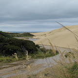
On our way back down the peninsula, we stopped to walk on the Giant Sand Dunes at Te Paki. There was a guy there named Dave renting boogie boards for dune surfing. We didn’t dune surf, but we did climb and walk on the closest dune and Helaine did slide down on the way back. These dunes seem to go on forever, but actually it is only about three kilometres to the sea. The Ninety Nine Mile Beach road cuts inland here and we did see one car heading in. Thankfully, it was low tide so the car wasn’t struggling. The signs warn of soft sand where some cars have actually sunk. That would not be fun.
It was late in the day when we stopped in Waiharara to see the Gumdiggers Forest. Kauri gum was once used to make varnish as well as beautiful jewelry. Unfortunately this place was permanently closed, but we enjoyed the ‘boot fence’ and huge trunks of Kauri trees in the parking area. Gum diggers had to wear knee high boots and the Wellies were displayed as a reminder of that. We had planned to drive further down the west coast today, but it was late we made a decision to drive out the Karikari Peninsula that was close-by and stay in the Top 10 in a town called Whatuwhiwhi–remember the ‘wh’ says the ‘f’ sound. As we drove the 16 kilometres to our destination, it became evident that food was not going to be readily available out here. We drove on and when we reached the Top 10 we saw Aunty Barbe’s Takeaway. It was the only game in town, so we had deep-fried fish, chicken, sausage, and chips for dinner tonight. That’s okay because this is a beautiful place and the very nicest accommodation we have had during our travels. We can see Doubtless Bay from our cottage window and will hope for a beautiful blue sky in the morning.
 |
| 070322 Web Pics–Kerikeri to Whatuwhiwhi |