by Judy Handley | Mar 7, 2007 | New Zealand Land Trip, Sailing Logs Year 2 |
NZ Land Logs 17, Year 2: South Island, Southern Tip–Papatowai
Date: Wednesday, March 7, 2007
Weather on the South Coast: Rainy, Rainy, Rainy, and Cool
Location: Papatowai, New Zealand
Our beautiful weather has left us and we woke this morning to still more rain. The temperature is cooler than it has been, but I actually have no idea what it really is–probably in the 50’s. I am still wearing sandals, but I have on jeans and a jacket. That keeps me warm enough, but there is a damp chill in the air that is not going to go away until the sun returns. Despite the weather, we persisted and had a great day.
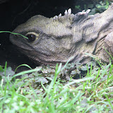
We left Te Anau and headed south. Our first stop was in Clifden (not misspelled) which is really just a sheep station. We went there to see a suspension bridge built in 1899. We had hoped to stop in the Dean Forest to walk through a reserve of 1000 year-old totara trees, but the weather and time pushed us on. We wanted to make a few more stops and still reach the Curio Bay 160-millon-year-old petrified forest during low tide. With that as our time constraint, we stopped in Riverton to see the Riverton Rocks. After all of the fantastic scenery we have seen in the past couple of days, the Riverton Rocks paled by comparison, but it was a great ocean-side stop and we could only imagine the surfers who sometimes are riding the waves here. Our next stop was in Invercargill to tour the Southland Museum & Art Gallery. The most exciting thing we saw here was Henry, a 110 year-old tuatara. A tuatara is a reptile that I never really expected
to see, so this was a very exciting stop for me. We traveled on to The Catlins. This is a beautiful part of New Zealand, but not as dramatic as the glacier and fiord area. The beauty today with the rain and fog was the green, green grass astures filled with thousands of white sheep. These pasture lands are on the edge of the Southern Ocean, so the total picture is quite beautiful. Our next stop was in Curio Bay and the petrified forest didn’t disappoint us. Seeing something that old is very special. Next we drove to Slope Point, the most southerly point on the South Island. There are New Zealand islands further south, but this seems like the end of the earth. On a rainy day, what might two sailors do? Well, Mark and Alan were in the front seat of the van and Alan had his GPS on the dashboard and Mark had his computer out and was following our trek with his navigation software. I felt like I was back on Windbird on passage. We reached the end of the road at Slope Point and recorded the GPS reading at 46 degrees 40.105 minutes South latitude by 169 degrees 00.036 minutes longitude. Alan entered this in his GPS just in case he sails this way some day.
It was now late in the afternoon and it was time to head to Papatowai for our night’s stay at the Hilltop. We had read in Lonely Planet that this backpacker was “far too upmarket to be a backpackers” and we weren’t disappointed. We drove to the top of a hill overlooking the ocean and found our home for the night. We are staying on a sheep farm and the sheep are literally at our front door and right outside the many picture windows. The farmhouse has beautiful flowers all around and is delightful inside. We are heating the house with a wood fire tonight and sharing the four-bedroom home with another couple from Toronto, Canada, Paul and Tama. They have a son doing a semester abroad in Dunedin and are here to visit him and explore. As I am writing this log, Mark, Alan, and Helaine are talking with Paul and Tama. We are really enjoying our evening here with new friends in this lovely place. Our bedroom for tonight has a huge picture window overlooking the sheep pasture and the ocean beyond. Even if it is still raining in the morning, which I assume it will be, I can’t wait to wake up and watch the sheep grazing right outside my window. All this and it is only costing us $65 New Zealand for the room tonight.
I love New Zealand.
by Judy Handley | Mar 6, 2007 | New Zealand Land Trip, Sailing Logs Year 2 |
NZ Land Logs 16, Year 2: South Island—Milford Sound
Date: Tuesday, March 6, 2007
Weather in Milford Sound Area: Rain, Rain, Rain
Location: Te Anau, New Zealand
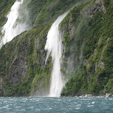
It was a rainy day for Alan’s birthday, but actually the rain enhanced our tour of Milford Sound. I’m sure it would have been beautiful if the sun had been shining, but we wouldn’t have seen the hundreds of temporary waterfalls that literally gushed from the mountain sides all around us. We had planned to do a couple of short walks on our way into the Sound, but the rain prompted us to put those off in hopes of a drier return trip. Our tour boat left Milford Sound at 10:30 am and returned at 1:00 pm. At first it was pouring rain with just a hint of sunshine which produced a rainbow for us. But quickly the sun went away, as did the rainbow, and the rain just kept pouring from the skies. We sat with a couple from the Los Angeles area, Carol and Maury who are touring Australia and New Zealand. Their daughter is doing a semester abroad in Melbourne and they are taking advantage of her location to see two spectacular countries. We enjoyed our conversation with them and then headed outside. We had to stand under overhangs in order to get pictures of the absolutely incredible waterfalls. The wind was blowing so hard at one point that it caused the falling water to actually turn and blow straight up. It looked like the mountains were smoking. As we left the Sound and got closer to the Tasman Sea, the rain slacked for a bit and we were able to go out on the front of the boat to see the Tasman up close. According to the boat’s captain, at times the wind was blowing 70 miles an hour and we were getting a little sea spray even up on the second level deck. When we reached St. Anne Point, our captain then turned the boat and we started the return to port in Milford Sound. He explained that Captain Cook had actually passed by the entrance to the Sound twice and never knew it existed. Seeing the way in is quite tricky even when you know it is there. As we reentered the Sound we could only see the lower parts of Mitre Peak which soars a mile above the water. The top was totally surrounded by clouds. We’ll just have to buy a postcard of that peak. The boat stopped in Harrison Cove to drop some passengers off at the Underwater Observation Center and then we were back in port.
It is very hard to describe the waterfalls that we were seeing today. Milford Sound is a fiord and the mountains drop straight into the sea. The mountains here are tree covered and green, but in some areas the cliffs are bare granite. This is where the sheets of water were flowing down the mountains. There were really hundreds of these waterfalls coming down from the mountains. The best I can do is to say that it was an incredible sight. On our way out of Milford Sound we stopped to do the Chasm Walk. Again, it was pouring rain but we wanted to the rock chasm formed by the waters of the Cleddau River. It was well worth getting wet to see and hear the waters of this river as they bounded over and around the rocky riverbed. That was our last stop on the way back to Te Anau but we enjoyed the views of the green and yellow fields in the wide valley rising to tree-covered mountains. At Mirror Lakes we hit the 45 degrees latitude mark. This is halfway to Antarctica, and as close as I am going to get to that continent. We saw one stand of Beech trees close to Milford Sound that signaled the arrival of fall. The leaves on these trees had already turned yellow. That’s the first time we have seen changing leaves. It is the equivalent of early September here, so I assume we will see more of this in the next month. Closer to Te Anau, the landscape changed and we found ourselves in a Beech forest that reminded us of New England. Then it was back to town to the internet cafe. Once emails are sent, we plan to see a movie at the Fiordland Cinema. Ata Whenua or Shadowland is a 35 minute film of Fiordland scenery. That will end our activities for today.
I have to make a correction to yesterday’s log. I only thought I was having chocolate fondant and berry coulis for dessert for my birthday. The restaurant has changed dessert menus, so I was forced to have Mascarpone and passion fruit cheesecake. It wasn’t chocolate, but it was yummy. It arrived with a candle and I was serenaded with a happy birthday song. As we left the restaurant, I stopped to take a picture of a framed t-shirt that was signed by the Lord of the Rings “stars.” A woman working in the restaurant came up and introduced herself as Megan Harvey, part owner of the Red Cliff Cafe and proud owner of the t-shirt. Then another gentleman came up to us that we recognized. It was Richard from the boat Lady in White. We had met him, and Barry and Marilyn that sail with him, a number of times on our journey across the Pacific. His wife from England flew in to land tour New Zealand with him and it was great to meet her and see a fellow cruiser down here in Te Anau. Once again we have evidence of what a small world it is. Leaving the restaurant we looked up to see some pretty spectacular clouds. They were piled like very thick pancakes in the sky–absolutely beautiful.
We leave Te Anau in the morning and head for the southern coast. We will visit Porpoise and Curio Bays and then spend tomorrow night at the Hilltop in Papatowai. Lonely Planet says this is an exceptional backpacker surrounded by rolling green hills and that it has amazing sunset views over the bay. Hopefully the rain will subside by then and we can enjoy a view of the Southern Ocean . On a clear day I know you can’t see Antarctica, but we’ll certainly enjoy a beautiful sunset if the weather cooperates. The owner of the Hilltop reminded us to bring our own food as there are no restaurants or stores in the area. Therefore, I am assuming that there will be no internet. The next logs will be posted as soon as we have a good internet connection.
by Judy Handley | Mar 5, 2007 | New Zealand Land Trip, Sailing Logs Year 2 |
NZ Land Logs 15, Year 2: Queenstown to Te Anau–Judy’s Big 60
Date: Monday, March 5, 2007
Weather in Milford Sound Area: Overcast and Warm
Location: Te Anau, New Zealand
As we left Queenstown this morning, the sun was shining. We have been so very lucky with the weather to this point with no rainy days, but we know our turn is coming–just not sure when. As we left Queenstown and headed south, we drove past The Remarkables. This is a “remarkable” mountain range that provides a ski playground in the winter. The south branch of Lake Wakapitu was on our left as we drove south and dramatic, yet very dry looking mountains rose on both sides of the lake. The mountains melted into rolling hills and pastures with lots of yellow grass and sheep. We also started seeing more venison farms the further south we drove. In what seemed like no time, it was time to turn to the west to Te Anau, our destination for today. Not only the dramatic mountains had melted away; the sunny weather had changed to overcast skies. There was more pasture land and more venison and sheep grazing in the expansive fields. As we neared Te Anau, dark mountains began rising in the distance. These are the mountains in the Milford Sound area that we will explore tomorrow.
We arrived in Te Anau and went directly to the Information Center and Department of Conservation Center to check out day walks in the area. We then went to Keiko’s Bed and Breakfast and checked in for our two night stay here. Since my birthday is today and tomorrow is Alan’s birthday, we splurged and decided to go up-scale and stay in the B & B. We actually have separate cottages and the whole place is picture book perfect. There are beautiful flower gardens around the cottages and even a little fish pond and garden in the back. Keiko is from Japan and Kevin is a local and they seem to have the perfect combination as hosts of a B & B. Kevin booked our tour of Milford Sound for us for tomorrow and gave us great information on the best day hikes to take. The forecast is for rain tomorrow, so we hurried on to have a quick lunch and walk just a little of the Kepler Track. The section of the track we chose to walk took us down along the banks of the Waiau River running out of Lake Te Anau. This is the second largest lake in New Zealand the views down the river once again brought us back to The Lord of the Rings. Four different rivers in New Zealand were used to represent the River Anduin in the movie and this was the third of the four rivers that we have visited. The bushy banks of this river were used in the first part of the journey undertaken by the Fellowship before they reached the Brown Lands. The path along the river was lined with ferns and moss and got darker and darker. We all felt like riders on black horses were going to tear down the bank from above us at any moment. I think we have been visiting too many Lord of the Rings sites!
Tonight is my 60th birthday dinner and we are going to a funky little place in town called the Redcliff Bar & Cafe. It comes highly recommended by Kevin here at the B & B as well as in The Lord of the Rings Location Guidebook. I’m definitely going to try venison tonight (Yes, I’m going to have Bambi for dinner.) with the recommended Central Otago pinot noir, and the chocolate fondant with berry coulis looks like my dessert of choice. Hey, you’re only 60 once.
by Judy Handley | Mar 4, 2007 | New Zealand Land Trip, Sailing Logs Year 2 |
NZ Land Logs 14, Year 2: South Island—Queenstown and Glenorchy
Date: Sunday, March 4, 2007
Weather in Queenstown: Another Beautiful Day
Location: Queenstown, New Zealand
Our little cottage at the Queenstown Top 10 Holiday Park Creeksyde is quite comfortable. As with our other accommodations, it has a kitchen and a bathroom, plus this one has a nice living room with an organ from the 1800’s. Not sure why that is in our cottage, but it certainly makes an interesting conversation piece.
Our first exploration of today took us to Glenorchy. This is a tiny little town on Lake Wakapitu, north of Queenstown. The road is tauted as spectacularly scenic in the literature, and we were not disappointed. Lake Wakatipu starts in Glenorchy where the Rees and Dart Rivers converge. It heads south and then makes a curve to the east to Queenstown, and finally it heads south to a town called Kingston. On the north leg of the lake, the landscape is dry with mountains on either side of the lake. Our first stop was Twelve Mile Delta, the land of Ithilien in The Lord of the Rings. We didn’t make it up stream to the area where Smeagol caught his favorite food, but we could just imagine Smeagol presenting his Coneys to the hobbits. Further along the road as we got closer to Glenorchy, we began to see snow-capped mountains in front of us. This is the land of the famous Routeburn walking trail and it was snow-clad Mt. Earnshaw and her surrounding peaks in Mt. Aspiring National Park that were the setting of the Misty Mountains in The Lord of the Rings. The Routeburn Trail will take you to the LOTR’s sites of Isengard, Amon Hen, and Lothlorien. Long ago the Maori came through this area in search of pounamu. This is the Maori word for jade or greenstone. The area then became a farming area, and then more than 3,000 gold miners arrived in the late 1800’s in search of that precious stone. Instead of gold they found scheelite, an ore used to make tungsten. Today Glenorchy is a center of adventure as the gateway to Mt. Aspiring Naitonal Park and the home to many sheep who graze along the shores of the Wakapitu Lake. On our trip back into Queenstown, we stopped in Closeburn for one more Lord of the Rings hits. Closeburn was one of three sites used for the climatic finale of The Fellowship of the Ring. The lake and the mountains most definitely bring Ithilien and Middle-earth to mind.
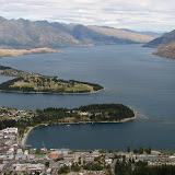
Back in Queenstown, it was time to ascend Bob’s Peak in one of the world’s steepest cable ways in the world. It rises over 446 meters in a distance of 731 meters and gives a spectacular view of Queenstown. At the top we enjoyed the scenic overlook and then is was back down for some town touring. We walked to William’s Cottage, the oldest home in Queenstown. Unfortunately it was closed, one of the few places closed in Queenstown on Sunday, so we didn’t get to see the inside. Instead, we sat on the waterfront and just enjoyed the views. We bought local salmon and fixed dinner back at our cottage. Tomorrow it is on to Te Anau and then to Milford Sound. Sure hope this beautiful weather continues.
by Judy Handley | Mar 3, 2007 | New Zealand Land Trip, Sailing Logs Year 2 |
NZ Land Logs 13, Year 2: South Island–Franz Josef Village to Queenstown
Date: Saturday, March 3, 2007
Weather Today: Bright Blue Skies with Lots of Sunshine
Location: Queenstown, New Zealand
Today was a beautiful day with lots of sunshine and bright blue skies. Our trip down the west coast from Franz Josef Village to Haast took about an hour and a half and brought us over mountains from glaciers to rich valley farm land. Haast, named after European geologist Julian Haas who was here in 1863, was once a gold mining town on the coast, but today is a center of farming-mostly cattle ranches. There were glacier views, high mountains, low river valleys winding their way to the sea, lush rainforest, and even a couple of high mountain lakes on the way south. Such diversity. We stopped at Knights Point to view the vast Tasman Sea. Often rough and stormy, the Tasman has been calm during our time here on the South Island. This area is a feeding ground for whales and sea birds, but today the only sea life we could see were seals basking on a point of land far below us on a calm sea.
In Haast we stopped at the Department of Commerce Information Center to watch a film about the area-The Edge of Wilderness. It was a bit dated, but gave a nice overview of the region. We met our only “Haastafarians”, the name the locals have given themselves, at the information center and it is obvious that the Kiwi accent gets a little stronger the further south we move. After Haast we headed inland toward Wanaka. We made our way up into the mountains and stopped at the Gates to Haast. This is a bridge across the Haast River near the top of the mountain and the river views were fantastic. We drove on and found ourselves at 563 meters in the Haast Pass which is in the Mt. Aspiring National Park. Mt. Aspiring is the tallest peak outside the Mount Cook area and it provided opportunity for more photos of beautiful snow-capped mountains.
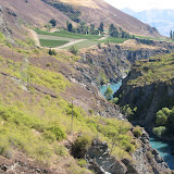
At this point the landscape changed. We were still in high country, but the green started fading and we were in a land of yellow and brown mountains covered with tussock grass and scrub. Our next stop was the Blue Pools Walk just north of a town named Makarora. A ten minute walk through the rainforest and across a swing bridge brought us to a river with crystal clear water and large brown trout that we could watch from an overlook. As we traveled on we drove along Lake Hawea with yellow-green mountains descending straight into the lake. Again, the scenery was breathtaking and is very hard to describe in words. Hopefully our photos will capture the beauty. We reached Wanaka in much less time than the charts indicated, probably due to the “expertise” of our drivers, Alan and Mark. A. J. Foyt’s skills pale in comparison! From Wanaka, we decided to leave Highway 6 and take the shorter, but much more challenging, Crown Ridge Alpine Scenic Road to Arrowtown. In our Lonely Planet guide to New Zealand (which has been invaluable), it said that this road would twist and turn, but would be half the mileage to Arrowtown. For the most part, the road was much less challenging than the warnings and soon we were passing the Cardrona ski area and the old Cardrona Hotel. It is one of New Zealand’s oldest, built in1863. The The Lord of the Rings Location Guidebook, also invaluable in our travels, says the pub inside looks suspiciously like The Prancing Pony in Bree. Unfortunately, we didn’t have time to stop and check this out. From the top of the mountain at 1076 meters (1086 meters according to Alan’s GPS) we had views of the River Anduin in The Lord of the Rings, the Pillars of the Argonanth, and the high hills of Dimrill Dale. Four different rivers were filmed as the River Anduin and this is the second of the four that we have visited. One meter further on there were views of the Ford of Burinen and Amon Hen nestled on the shore of Nen Hithel far in the distance. From these viewpoints, we were looking down on beautiful green fields of farms and vineyards and Lake Wakatipu in Queenstown . All around us were mountains that are not snow-covered at this time of year. We could only imagine how beautiful the scene would be with the snow. From the top of the mountain, we started our descent. This is when the real twisting and turning began. Seven hairpin turns later we reached the valley floor and made a left turn to take us to the Chard Farm Vineyard and to A. J. Hackett Bungy. This is the western end of the Central Otago wine region which is known for its great Pinot Noirs. The drive to the vineyard was a one lane, unpaved gravel road on the edge of a cliff overlooking the Kawarau River. The wine at the end of the road was much needed after that drive. From there, we retraced our steps back to the A. J. Hackett Bungy Jump center-quite an impressive little operation using the historic Kawarau Suspension Bridge for its jumps. We figured they bring in $3,000 an hour with a jump every 3-5 minutes. We watched a few jumps and decided that we would continue to be “watchers”, not participants, in this sport. We knew that the idea of bungee jumping came from a native ritual in Vanuatu, but we didn’t know that it was made famous by A. J. Hackett. In the late 1980’s, Hackett and speed skier, Henry Van Asch, were fascinated by the Vanuatu custom and after watching videos at the Oxford University Dangerous Sports Club, Hackett jumped form the Eiffel Tower. This jump in 1987 created great interest and the Kawarau Suspension Bridge became the world’s very first “bungy bridge.” It was certainly a busy place today. We enjoyed watching the jumps into the Kawarau River. This site was used as the Pillars of the Kings in The Lord of the Rings, but many of the pillars were superimposed on the real landscape. Even with the extra pillars, it was a dramatic site.
Our last stop was Arrowtown. This is a quaint little town that was once a booming gold mining town. We walked down the main street and looked at the 60 original wood and stone buildings. Alan and Helaine did some shopping and bought a beautiful wool sweater for Alan. Many of the sweaters here are made from a combination of Merino wool and possum fur. It is so very soft. We thought about making a refreshment stop at The Tap, an authentic gold town building, but again time pushed us on. We finally reached Queenstown and actually had time to relax before heading out to dinner in this busy center of New Zealand adventure. Even at 10 PM when we walked back to our cottage, the town was still buzzing. Tomorrow we will explore the Queenstown and Glenorchy areas before heading to Milford Sound. This adventure just gets better and better.
by Judy Handley | Mar 2, 2007 | New Zealand Land Trip, Sailing Logs Year 2 |
NZ Land Logs 12, Year 2: Fox and Franz Josef Glacier Adventures
Date: Friday, March 2, 2007
Weather in Franz Josef Glacier Region: Overcast Skies with Patches of Sunshine
Location: Franz Josef Village, New Zealand
The days just get better and better. This morning we headed 25 kilometers south of here to the Fox Glacier area. First we did an hour and half walk around Lake Matheson which gave us phenomenal views of the Aoraki/Mt. Cook and Mt. Tasman. They are both snow-capped and beautiful and we could see the glaciers heading down the mountains. We did this walk first based on Lonely Planet recommendations. The clearest views of the glaciers are in early morning or late evening, so we chose the early morning for our first views of the mountains. Lake Matheson offers view points where you can get photos of the snow-capped mountains with their reflections in the lake. It was absolutely beautiful even though we didn’t have clear blue skies.
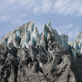
We left Lake Matheson and headed for the Fox Glacier. It was a 40 minute return walk from the car park to the terminal face of the glacier. We were wearing long pants and long sleeve shirts. There was an icy wind blowing down from the glacier, but it was not enough to make us put our jackets on. We walked up the valley beside the rushing stream of water coming from the glacier and truly enjoyed the sights. We were about a football field away from the end of the glacier when we reached the roped off area and that was close enough for us. When we returned to the van, we headed north again to the Franz Josef Glacier.
The Franz Josef Glacier is larger than Fox, but both are amazing. In order to get to the terminal face of Franz Josef we had to walk for about 45 minutes up a wide, rocky, and dry riverbed. Again, we could not actually get close enough to touch the glacier but we were close enough to get great views. All in all, we probably walked about seven miles today. When we got back to the campground, we immediately made a reservation for the spa. That was a great way to relax very tired feet and legs. We then made dinner in the communal kitchen of our lodge and are currently sitting in the communal room editing pictures, talking to a couple of guys from England who walked on the glaciers today, and just generally enjoying our adventure. Tomorrow morning we head for Queenstown with a few stops on the way. There are some Lord of the Rings filming spots on the way that we want to check out.