by Judy Handley | Mar 8, 2015 | Bahamas, Sailing Logs Year 10 |
Day 149, Year 10: The Exumas . . . At Last
Date: Sunday, March 8, 2015
Weather: Partly Sunny, Winds NE 15-20, Great Beam Reach Sailing
Latitude: 24 36.040 N
Longitude: 076 49.418 W
Location: Anchored on West Side of Normans Cay, Exumas
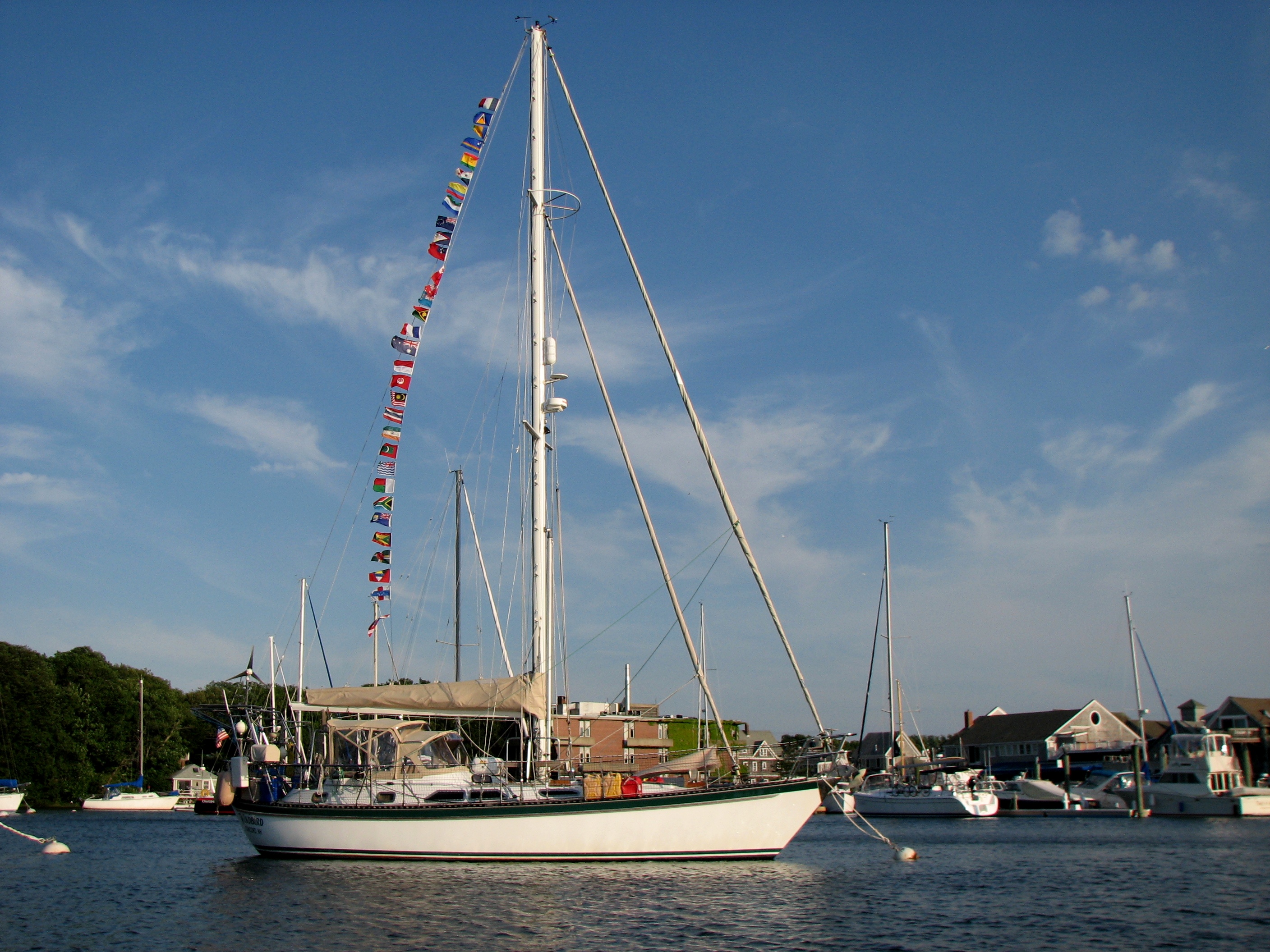
For Mark and me, it has been more than two years of waiting to finally reach the Exuma Islands in the Bahamas. In the fall of 2012 we left Cape Cod thinking we were headed to either Puerto Rico or to the Exumas in the Bahamas. We got as far as Little River in South Carolina and Mark made the decision that he wanted to stay there for the winter. It is a comfortable place to stay and we really enjoyed a winter of visiting with my sister Patsy and her husband Joe. But we didn’t make it to the Bahamas. We went back to Cape Cod for the summer and thought we would be headed to the Bahamas in the fall of 2013. But just a few days before we left, we found out that Mark’s cancer had returned and that we needed to stay in Massachusetts for the winter so he could undergo treatment. So once again, we didn’t make it to the Bahamas. Fast forward to September of 2014. Mark had undergone a second surgery and the doctors were convinced that he was cancer free. But then, just a few days before departure for the Bahamas, we found out that the cancer had returned. But this time, Dr. Kwak, his oncologist, insisted that we go ahead and sail south. She was determined to find a way that Mark could get the necessary cancer treatments and still make it to the Bahamas. And so she did make that happen, and now we are here. Surely we can find a post card somewhere here in the Exumas to send to Dr. Kwak. Better yet, I need to figure out how to send an electronic post card with a picture of Mark on Windbird in these beautiful turquoise waters. It feels wonderful to be here and we have nothing but thanks and praises for a doctor who helps patients make dreams come true.
We had a great day. From the Nassau area, you can get here by going the short way across the Yellow Bank (lots of coral heads to negotiate) or the longer way across the White Bank (fewer coral heads). We chose the longer route with few coral heads. It was only about 30 minutes of careful watching, but as I stood on the bow looking for those dreaded ‘heads’, it seemed like an eternity. But we made it and we were able to sail all the way from Rose Island. We were on a beam reach with 15 to 20 knots most of the day. It was lively, but not really rough. And now we are here!!! Tomorrow we will explore around Normans Cay before heading further south.
by Judy Handley | Mar 7, 2015 | Bahamas, Sailing Logs Year 10
Day 148, Year 10: Chub Cay to Rose Island (East of Nassau)
Date: Saturday, March 7, 2015
Weather: Beautiful Weather for Motoring, Winds E 5, Flat Seas
Latitude: 25 04.997 N
Longitude: 077 12.681W
Location: Anchored on the South Side of Rose Island, Just East of Nassau
It was a beautiful day . . . for motoring, but not for sailing. But still it was a beautiful day. Lee has a theory about sail boats. I’m not sure I have the theory exactly right, but I think it is basically that sailboats have a magnet in the bow that attracts wind. Therefore, you are always sailing directly into the wind. And it seems that we either have winds on the nose or we have winds directly behind us. I guess that would be the opposite theory that states there is a magnet on the stern of the boat attracting wind to it. We haven’t had a lot of great sailing days since leaving South Carolina in late December, but we are still having fun.
Windbird and Sea Turtle left the anchorage at Chub Cay just before 8 am this morning and motored the 44 miles due east to Rose Island. This is a small island to the east of New Providence Island, home of Nassau. We had no desire to get this close to Nassau, but there is really no other anchorage between Chub Cay and the Exumas. And tomorrow we will be entering waters where there are coral heads making an overnight impossible. So Rose Island is our home for one night. Tomorrow night we will be in the Exumas, hopefully anchored off Normans Cay. We won’t get there until very late in the afternoon, so we hope to do a little exploring on Monday morning before heading further south to Shroud Cay. The reason we will get there late in the day is because we have to time our departure here to reach the area between the Yellow and White Banks where there are scattered coral heads when the sun is high in the sky. That area is only two hours from here, so we can’t leave too early. And this brings up a time question. Chris Parker, our weather guru, announced this week that the time changes tonight to Eastern Daylight Time, at least the time for his broadcasts. What we don’t know for sure is whether or not the Bahamas go to Eastern Daylight or stay on Eastern Standard. The tide charts we have indicate that they do. So until we find out for sure (not easy without internet), we will spring forward and go with Eastern Daylight. And that brings up the internet issue. Phone and internet issue here is tricky. Our provider is AT&T and we could have paid to have limited service. But it was very limited. Or we could purchase a SIM card here and buy time for Bahamian phone and internet service, but this comes at a greater cost than we are willing to pay. Our solution was to simply turn off our phones. We use our HAM radio for email communication and we will buy wifi time when it is available. That means that photos will be posted only when we have wifi available and it also means that we can’t look up the answers to simple questions. How did we ever function without the internet?
When we got to Rose Island it was almost 6 pm. It took us longer to get here than expected as we had adverse current most of the day. We launched our dinghy and Mark went over to pick up Lynda and Lee. We invited them to come over so we could have a planning meeting. We spent an hour discussing our schedule for the next couple of weeks. We have a basic plan, but the details have to be decided each morning after we hear the latest weather report. This week we will be heading south and the winds will be coming from the SE, stronger on some days than others. So we’ll try to match our travel days to the days with least wind. It looks like we could have really strong winds on Friday, so we’ll want to tuck into a good anchorage before then to ride out the winds. It seems that you have to be on constant weather watch in these parts.
by Judy Handley | Mar 6, 2015 | Bahamas, Sailing Logs Year 10 |
Day 147, Year 10: Checked-in and Ready to Explore
Date: Friday, March 6, 2015
Weather: Sunny and Hot, Light Winds SE to ESE
Latitude: 25 24.629 N
Longitude: 077 54.610 W
Location: Anchored at Chub Cay, Berry Islands, Bahamas
We made it! Windbird and Sea Turtle are checked-in and ready to explore. The decision was made to sail through the night and it was a great decision. Once we were on the Grand Bahama Bank the winds and seas calmed down and the full moon rose to give us light . . . and a light show on the water. The light of the moon danced on the water and looked like phosphorescent fairy dust laying a path for us to follow. Magical. Otherwise, the night was uneventful and we reached Chub Cay around noon. The Chub Cay Club dominates this small island. There is a marina with great docks but almost no boats, a fuel dock, the Club with a restaurant and rental homes, a small village where the workers live, a little store and laundry in the village, and the airport for private planes. The Chub Cay Club serves sport fishermen as the fishing in this area is fantastic. There are a few big fishing boats, but most fishermen must fly in. The Club charges a $100 to allow sailors to become guests for a day and check into the country. But they let you apply the $100 toward diesel fuel ($4.90 a gallon) and water ($ .40 a gallon), so basically we filled up our fuel and water tanks, checked in, and then headed out to the anchorage. Lee and Lynda stayed inside long enough to do laundry, but tonight we are both anchored out and will continue on tomorrow. It is too far to get to the islands of the northern Exumas in one day, so we will stop tomorrow night at a small island to the east of Nassau, making landfall in the Exumas on Sunday. The weather today was gorgeous, but with light winds, it was hot. We dare not complain, however.
The weather reports we are getting from friends and family all along the eastern seaboard from South Carolina to Massachusetts say that they are still having colder than normal weather. And as of yesterday morning, it was still snowing on the Cape. Sure wish we could send some of this sunshine and hot weather up north. But spring will come. Our weather guru, Chris Parker, announced this morning that Daylight Savings Time begins on Sunday morning. He also said that a huge weather front coming through on Friday the 13th of next week looks like it will be the beginning of a different weather pattern. Here as well as up north in the US, the same pattern has been cycling for weeks bringing colder than normal weather and lots of precipitation. Chris predicts that is going to change and warmer weather will ‘surely’ follow.
by Judy Handley | Mar 5, 2015 | Bahamas, Sailing Logs Year 10 |
Day 146, Year 10: Almost There
Date: Thursday, March 5, 2015 @ 5:45 pm
Weather: Sunny and Hot, Winds SE 15-20 AM, SSW 8-10 PM
Latitude: 25 54.217 N
Longitude: 079 20.626 W
Location: 5 Miles from Entering the Grand Bahama Bank; 52 miles from Key Biscayne
After listening to the morning weather report, we decided to go for it. It is now early evening and we are still not quite on the Grand Bahama Bank, but we will be there just after sunset and continue on until around midnight. At that point, we (Sea Turtle and Windbird) will simply drop our anchors and sleep for about six hours before continuing on. At least that is the current plan. We could just motor sail on overnight, but not sure everyone is up for that. The goal is to reach Chub Cay in the Berry Islands tomorrow, check in, and then continue on to Rose Island just west of New Providence Island (Nassau) for Saturday night. On Sunday we will start the trek south through the Exumas, weather permitting.
If you are not familiar with the Bahamas, this probably all sounds like a bit like Greek. So here are my quick notes to help you better understand the territory. The Abacos and Grand Bahama Island (Freeport) are on the Little Bahama Bank. These places are in the northern Bahamas and at the closest point are about 50 miles due east of West Palm Beach in Florida. Bimini and Cat and Gun Cay are further south and are about 50 miles due east of Miami and are on the Grand Bahama Bank. Mark’s definition for the ‘bank’ is simply, “A shallow place.” So we left Miami heading across to Bimini BUT the Gulf Stream runs rapidly north in the waters between Florida and the Bahamas. If you want to go east, you have to sail south. And since we left with strong SE winds, we were carried further north than we would have liked, but we knew the wind was going to die mid-afternoon and that we could then make our way back south. Of course, the wind went further south as well, so we are still motor sailing into the wind, but it is now only 7-8 knots with 1-2 foot seas. That’s a whole lot better than 15-20 with 6-7 foot seas. We could have waited until tomorrow and motored the whole way, and in retrospect, maybe that would have been smarter because this morning was rough. Mark and Lee talked on the VHF radio a number of times today about navigation issues, but we had really not heard how they are doing. So I just called and Lee said his butt is sore from sitting behind the wheel all day and that Lynda spent most of the day below sleeping. So she should have lots of energy tonight! The seas and winds are calming down nicely, so hopefully it will be a relaxing night on the water, whether we anchor around midnight or keep on motor sailing.
Now back to the notes about the geography of the Bahamas. We have the Abacos and Grand Bahama Island to the north of us and Bimini and Cat and Gun Cay to the south. Just a couple of minutes ago Mark yelled out, “Land Ho.” We can see Bimini, but we are not going to stop there. We are headed right on to the Grand Bahama Bank and will end up in the Berry Islands tomorrow (Chub Cay). From there we will sail about 35 nautical miles to Rose Island just east of New Providence Island (Nassau). To the east of there is Eleuthera and to the south is the chain of small islets (called cays, pronounced keys) of the northern Exuma chain. This is where we will be spending all of our time. Further south is Great Exuma and Little Exuma Island and the cruising mecca of Georgetown. To the east of there is Long Island and Conception and to the south the Bahamas continue to the southeast all the way to the Turks and Caicos. South of there you in the British and US Virgins.
So, yeah, we are here. I got my birthday wish. The one thing I didn’t want for my birthday, however, was a website that is not working. But I got that, too. For some reason, when I tried to get on handleysail.com this morning, I got an error message. It is like the website is just no longer there. I sent an email to Justin and hopefully he will be able to get this fixed. But the timing was horrible. I am sending this log directly to a number of you and hopefully Justin will be able to get the website back up and running soon. Patience, patience . . . not one of my virtues!