by Judy Handley | Nov 14, 2012 | Passage to South Carolina, Sailing Logs Year 8 |
Day 11, Year 8: ICW Mile 12 to Mile 50, Great Bridge to Coinjock
Date: Wednesday, November 14, 2012
Weather: Partly Sunny, Winds Starting at NE 4-6, Building to NNE 25-30
Latitude: 36 20.987 N
Longitude: 075 56.886 W
Location: Intracoastal Waterway, Mile 50, Coinjock, NC
The day started out on a calm note, but unfortunately that all changed
before noon. During the morning we made our way through the cypress swamp
sighting a bald eagle and a deer swimming across the canal right in front of
us. The cypress swamp turned to grassy swamp as we entered the Currituck
Sound and then the wind piped up. By the time we were crossing that broad
open expanse of water, the winds were a good 25 to 30 knots. We had hoped
to go beyond Mile 50 tonight and anchor closer to Mile 60. but the only
anchorage deep enough for Windbird didn’t look like it would be all that
protected. So we stopped at Mile 50 at the Coinjock Marina. It was early
in the day and since we have so many miles to go, we really hated stopping
so early and having to pay to stay in a marina, but in the end we were
really glad that we made that decision. A boat that was in front of us this
morning, New Wave from Portsmouth, New Hampshire, went on past Coinjock to
go to the anchorage that was our original destination. Then another
sailboat went by headed in that direction. We were feeling very guilty for
not going on, and then about that time, both sailboats returned. We met
Bill and Cathy on New Wave and they explained that when they got to the
anchorage area the wind was roaring and there was very little protection so
they had to turn around and come back the ten miles to Coinjock. They move
a bit faster than Windbird, so if we had done the same thing, it would have
been dusk by the time we got back here. Prudence won in this instance.
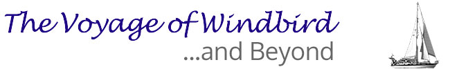
We had dinner with Bill and Cathy who are on their way to the Bahamas after
a stop in Myrtle Beach for a few weeks while they fly back to New Hampshire.
Bill is a professor at UNH and needs to finish up the semester before his
year-long sabbatical begins. After 42 years as an elementary teacher, Cathy
is retired. She started teaching a year after I did in 1970. During dinner
we talked about education and about the weather, which is not being very
cooperative, and the few and far between anchorages we have to choose from
in the next couple of days. We have a lot in common and it was nice to meet
another couple making this trip. Mark and I are finding the transit through
the Intracoastal a bit tedious. The winds today were way more than
predicted and it was hard to steer Windbird. We had the dinghy on the
davits on the back of the boat, and we think that made the steering more
difficult than it should have been. We have now put the dinghy back on the
front deck. And it is chilly. But the biggest problem is the lack of safe
havens for anchoring at night. Tomorrow we will start at first light and
try to make it to Mile 161. It will be a long day but at least the winds
will still be coming from the north pushing us along. Our first obstacle
tomorrow morning will be getting off this dock with the wind blowing us onto
the dock. I’m hoping there will be an early morning calm.
by Judy Handley | Nov 13, 2012 | Passage to South Carolina, Sailing Logs Year 8 |
Day 10, Year 8: ICW Mile 0 to Mile 12, Norfolk to Great Bridge
Date: Tuesday, November 13, 2012
Weather: Overcast with Rain, Temp 50’s; Wind NE 18-22 am, NNE14-16 pm
Latitude: 36 43.244 N
Longitude: 076 14.264 W
Location: Intracoastal Waterway, Mile 12, Great Bridge, VA
Never a dull moment! What was supposed to be a non-eventful 12 mile day
turned out to be quite the opposite. It was still 12 miles, but there was
nothing non-eventful about it. At 7:30 am the wind started roaring and the
rain started pouring . . . and the anchor started dragging. That’s a rude
way to start the day. Mark started the engine and tried to steer us clear
of the two boats, one on either side of us. While doing that, I heard a
CLUNK and the engine stopped dead. There’s only one thing that makes a
noise like that and that is when you have something wrapped around the prop.
I was down below and could hear it clearly, but Mark was in the cockpit and
didn’t hear the CLUNK, so he thought he was out of fuel. He ran down the
companionway steps to go switch over the fuel while I am trying to tell him
that I think we have a crab pot line wrapped around the prop. It all
happened so fast and he was back in the cockpit starting the engine again,
and again CLUNK and the engine stopped dead. He now realizes that we do
have a line wrapped around the prop, so he goes up to release more anchor
chain. He felt like we had stopped dragging and putting out more chain with
the 25 knot gusts seemed like a good idea. It worked. We had stopped
dragging and the extra chain kept us from breaking loose again. It’s a good
thing because the wind was blowing us into the bay that the charts say have
less than a meter of depth. Running around and having no engine are not a
good combination. In tropical waters, Mark would have been in the water
right away to cut away the line, but Norfolk in November does not equal
tropical waters. So Mark got on the phone and called a nearby marina to see
if they could recommend a diver. They said they’d call back, so we called
another marina. By this time it is 8:30 am and by the time the second
marina called back saying that they found a diver it was close to 9 am.
Somewhere in here we ate breakfast and put on our foul weather gear. Then
we lowered the dinghy and motor so Mark could go to shore to pick up the
diver. He was gone for over an hour and a half before he returned with Sam
the diver. In the time he was gone, the wind increased to gusts of 28.
Needless to say I was a bit panicked knowing there was nothing I could do if
we started dragging again. We were being blown toward a yellow buoy and I
had thoughts of trying to use a rope to lasso it if I got close enough, but
the chances of that being successful were probably very slim. It was after
10:30 when Mark returned with Sam. Mark had been standing outside all this
time waiting for him and he was chilled to the bone, but he had to stay down
in the dinghy to help recover the crab pot and put new line on it. When Sam
finished cutting away the line, we started the engine and everything seemed
fine, so a few hours and a hundred dollars later, Mark took Sam back to
shore and then we brought up the anchor and started up the ICW. Mark had
pulled three crab traps onboard so we wouldn’t snag another pot while
getting the anchor up. There were some beautiful crabs, but as soon as we
could, they went back in the water and we were on our way. It was 12:20 pm
and the wind and the rain had calmed down a bit. Negotiating the bridge
openings was much easier than we had thought and by 3 pm we were tied to the
free dock on the east end of the Great Bridge Bascule Bridge. We did not
have to wait more than 10 minutes for any bridge to open and the lock tender
saw us coming and called on the radio to tell us to speed up if possible.
We assumed we were going to have to wait an hour but they waited five
minutes for us and we made it just fine.
We took a little walk once we arrived. The dock we are tied to was supposed
to be adjacent to a new Visitors Center for the Great Bridge Battlefield and
Waterways Park. The parking lot was completed and a beautiful walkway with
historic sign posts explaining the importance of the Battle of Great Bridge
during the Revolutionary War, but there are only foundation posts for the
Visitors Center. Since it was supposed to be completed in 2010, we figure
they must have run out of money. We enjoyed reading about the first land
battle of the Revolutionary War in Virginia and America’s first victory-at
least that is what the signs say.
We are hoping for a much calmer beginning tomorrow morning. The next bridge
is closed from 6:30 am to 8:30 am during early morning rush hour, and we are
not going to try and get there at 6:30 am. So we will depart here to go
through at 8:30 and then continue on to Mile 50 in Coinjock, North Carolina.
Mark wants to go to the marina there instead of going on to Mile 61 to an
anchorage. I think the decision will be made depending on the weather and
the time of day. It is about 350 miles from Norfolk to Myrtle Beach. It
will have taken us two days to get to Mile 50, but after that we are hoping
to make 50 miles each day. If the weather is perfect and we can go outside
at Beaufort, NC, we might make it to Little River on Monday. If not, we
won’t get there until Tuesday. But no worries, Patsy. We will be there in
time to cook that Thanksgiving dinner.
by Judy Handley | Nov 12, 2012 | Passage to South Carolina, Sailing Logs Year 8 |
Day 9, Year 8: Piankatank River to Norfolk
Date: Monday, November 12, 2012
Weather: Mostly Sunny, Temp 70 degrees F; Wind SE 16-18
Latitude: 36 50.780 N
Longitude: 076 18.052 W
Location: Intracoastal Waterway, Mile 0, Across from Downtown Norfolk
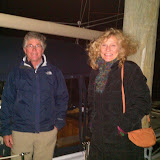
We had great winds again today, but as yesterday, they were right on the nose. So we motor sailed the 50 plus miles from Jackson Creek in the Piankatank River to here. It was mostly sunny but a bit hazy as the day progressed, probably because of the warm 70 degree temperature. It was delightful. And being Veteran’s Day, it was fitting that we motored past the aircraft carriers and battleships at the Navy Base in Norfolk. It took us almost three and a half hours from the first mark leading into Norfolk to get to this anchorage. We had strong current against us, but even without that, it is a long way in here. We anchored just past Hospital Point on the Portsmouth side of the Elizabeth River which is directly across the river from downtown Norfolk. We can look across and see Nauticus, the National Maritime Center. This is where the USS Wisconsin, one of the largest and last battleships built by the US Navy, was stationed upon retirement. It was commissioned on December 7, 1943, and was retired after Operation Desert Storm in the early 1990’s. We toured it in 2001 when we sailed Windbird to New England from Florida just after we purchased her. We won’t have time to visit again this trip, but maybe on the way north in April.
We had great Skype video calls with both of our children this evening. Sam and Jonah drew pictures for us while we talked and in between smiles, Oliver just kept staring at the computer screen. It seemed like he understood when we said his name. When Justin called from New Mexico we found out that the weather there has turned very cold. The daytime temperature today was in the 40’s and the nighttime temp last night was 16 degrees F. Burr. But Ziggy and Coco are both doing great. Ziggy read a book about shapes and shared the triangle page with us as it had a picture of a sail. And then he turned on his CD player and performed a little dance. Coco was still bundled from going on a walk with Jo and Ziggy, but she finally warmed up and gave us lots of smiles.
Tomorrow morning we have to run the gauntlet. We are at Mile O on the ICW and will only make it to Mile 12 tomorrow.
Mile 2.6: We go through the N&P Beltline Railroad Lift Bridge that is normally open. If it is not, we will have to wait for it to be raised.
Mile 2.8: We pass the Jordan Highway Lift Bridge which has been dismantled. So this is no problem.
Mile 3.6: We go through the Norfolk and Western Railroad Lift Bridge which is normally open. We are hoping for a normal morning.
Mile 5.8: Here we meet our first obstacle. The Gilmerton Bascule Bridge is closed from 6:30 to 8:30 am (and 3:30 to 5:30 pm) so we have to time our departure from here to reach there no earlier than 8:30 am. At this same location we go through the Norfolk and Western RR Bascule Bridge which is normally open. Again, we are hoping for a normal morning.
Mile 7.1: We go under the Highway Bascule Bridge (Interstate 64) which is SUPPOSED to be 65 feet high which we SHOULD fit under . . . barely.
Mile 8.8: The Dominion Boulevard Bridge (aka “Steel Bridge”) opens on the hour between 9 am and 4 pm, so we just have to time our arrival here to be just before the hour.
11.3: The Great Bridge Lock opens on the hour, so again we just go very slowly from Mile 8.8 to 11.3 to arrive on the hour.
12.0: Our last hurdle of the day is the Great Bridge Bascule Bridge which opens on the hour timed to open with the Lock. Once we go through this bridge, it is our hope that there will be room along a face dock to tie up and spend the night. There are no more overnight spots deep enough to accommodate Windbird until we get to Mile 50, and there is no way to make 50 miles in a day with the waits associated with bridge and lock openings. So tomorrow will be a short day with many starts and stops. And to add to the excitement, it is supposed to rain. We’re not looking forward to that.
by Judy Handley | Nov 11, 2012 | Passage to South Carolina, Sailing Logs Year 8 |
Day 8, Year 8: Great Wicomico to the Piankatank River
Date: Sunday, November 11, 2012
Weather: Another Beautiful Day, Temp in the 60’s F; Wind S 12-14
Latitude: 37 32.684 N
Longitude: 076 19.965 W
Location: Jackson Creek Off Piankatank River, VA
What a delightful day. The weather was perfect except for the south winds
right on our nose, but we just turned on the engine and motor sailed our way
about 24 miles south. We got here at 4:30 pm, so our choice was a good one.
We didn’t want to come in after sunset again tonight. We started our day by
having Kevin and Claire over for breakfast and then we all got in the dinghy
and headed out to a nature preserve on the south side of Ingram Bay. I
think this area is called Dameron Marsh or maybe Hughlett Point. Whichever,
I read on the internet that it is the largest wetland on the western side of
the Chesapeake Bay, but “unfortunately it suffers from extremely severe
erosion. We can attest to that. Kevin and Claire were here just three
weeks ago, but when we beached the dinghy and they looked around, they
couldn’t believe the changes. There were no sand dunes and the shape and
size of the beach were totally changed by Hurricane Sandy. They have always
been able to walk around to the south side of the spit of land and then make
their way along a beach on a point that goes right on out into the
Chesapeake. No more. There was no more beach to walk. It was simply gone.
So we walked as far as we could and enjoyed the beauty as it is now. We
then went back to Windbird and had the other pint of ice cream that was too
hard to eat last night. I’ve never had ice cream in the morning, but Cherry
Garcia tasted great. We really enjoyed our short time with Kevin and Claire
and invited them to come to the Bahamas to see us there. And we’ll hope to
stop by this way again in the spring on our way north and explore a little
more of the Chesapeake with them.
We are anchored at the mouth of Jackson Creek with five other boats. I’m
sure we will all be on our way early in the morning, trying to make Norfolk
with a south wind and a shortened day. This 5:15 pm sunset severely
restricts our travel time.
by Judy Handley | Nov 10, 2012 | Passage to South Carolina, Sailing Logs Year 8 |
Day 7, Year 8: Patuxent River to Great Wicomico River
Date: Saturday, November 10, 2012
Weather: Another Beautiful Day, Temp High 50’s F; Wind SE 10
Latitude: 37 37.522 N
Longitude: 076 19.363 W
Location: Mill Creek Off Ingram Bay, Great Wicomico River, VA
The weather gets just a little warmer each day and the sun keeps shining. It looks like we will meet up with windy, rainy weather on Tuesday, but we’ll keep enjoying these beautiful fall days while they last. We got up and had a leisurely breakfast with Ron and Suzie so didn’t leave Leason Cove until 9:30 am. Before we left, Ron showed us their little oyster ‘farm’ that is attached to the dock. Ron and Suzy and many of their neighbors grow these oysters and then release them in order to help boost the diminishing oyster population. We then got the official ‘cheerleader’ farewell on the dock. A few years ago when I first met Ron and Suzy, they somehow found out that I was a cheerleader in high school and they aren’t going to let me live that one down.
We had 10 knots of wind on the nose today and didn’t get current going our way until late afternoon. It wasn’t until we were passing the mouth of the Potomac that we got a little boost from current. We ran the engine at almost full throttle all day and watched a beautiful sunset just as we were rounding the last marks to the entrance to Mill Creek. It was dusk when we reached the anchorage so we barely made this one. We had a little trouble getting the anchor to stick but since there is no wind and very little current in here, we finally decided we were secure enough. We launched the dinghy and headed over to Merganser for dinner with Kevin and Claire. Kevin put fish on the barbeque and Claire made a red grapefruit and roasted fennel salad. It was yuumy. But the best part of dinner was dessert (or at least it was the most fun part). Kevin and Claire brought ice cream packed in dry ice. The ice cream was a great idea, but the dry ice did its job too well. The ice cream was frozen so hard that we were able to clink it with knives and make music. Kevin and Claire were playing Cherry Garcia and Mud Pie. It was great. Then Kevin attacked the Mud Pie with a knife, missing once and stabbing his thumb, so that we could finally eat the ice cream. We had a lovely dinner, caught up on each other’s lives, and made plans for tomorrow morning. Kevin and Claire will come to Windbird for breakfast and then we will head out in the dinghy to do a little exploring. There are dolphins and pelicans in this part of the Chesapeake and so many birds. Kevin and Claire were greeted by a flock of mergansers when they arrived earlier today. Merganser met mergansers. We will find a beach to explore and then just before noon, we will pull up that anchor that we aren’t sure is securely stuck in the mud and head to either Deltaville or Jackson Creek in the Piankatank River just south of the Rappahannock. It is only about 20 miles, so hopefully we will arrive before dark.
by Judy Handley | Nov 9, 2012 | Passage to South Carolina, Sailing Logs Year 8 |
Day 6, Year 8: Annapolis to the Patuxent River
Date: Friday, November 9, 2012
Weather: Beautiful Day, Temp Around 50 degrees F; Wind NW 15-20
Latitude: 38 19.883 N
Longitude: 076 26.175 W
Location: At Home with Ron and Suzie Williams, Leason Cove, Lusby, MD
It was a beautiful, sunny day in the neighborhood and we had a nice downwind
sail from Annapolis. Mid-day the wind calmed a bit and we were headed too
directly downwind, so we rolled up the headsail and motor-sailed the rest of
the way. We pulled right up to Suzie and Ron’s dock and then-thud-we were
aground. It was low tide and we knew it was going to be close. Later this
evening, Windbird floated off the bottom, so we know that we will be able to
get away in the morning as the tide rises. Ron and Suzie took us to the
grocery store and invited us to use their washer and dryer to do our
laundry, so by dinner time all our land-based chores were done. We had a
wonderful dinner and then got to watch one of the videos that Ron edited of
their recent diving trips while visiting Culebra Island in Puerto Rico. It
was a wonderful evening. Tomorrow we will stay around for breakfast as we
can’t leave until the tide rises. But when Windbird is floating again at
morning high tide, we will be on our way south to meet up with our friend
Kevin and Claire. The march south continues.